
Madrid Metro map
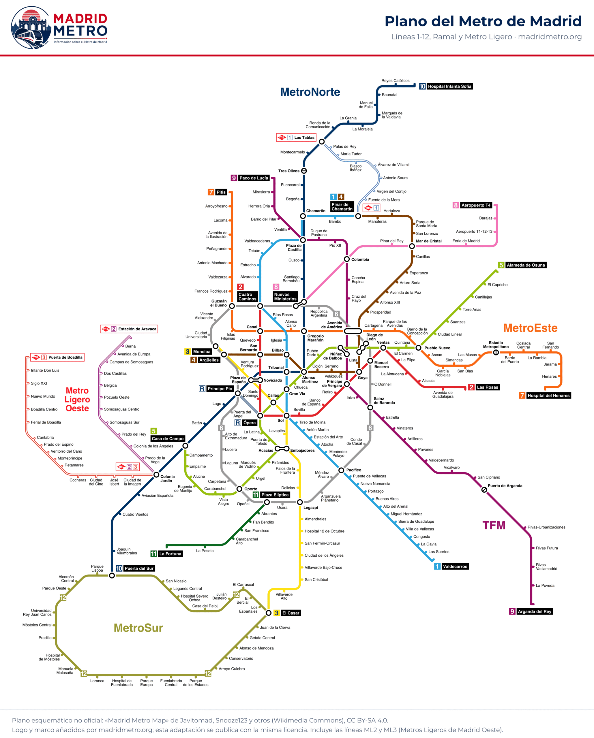
Every line and station on one map, including the Metro Ligero light rail. Tap to enlarge it or download the PDF.
Metro map as a PDF
Madrid Metro map · PDF
Vector PDF: it stays sharp however far you zoom in. Save it on your phone for when there is no signal.
How to read the map
Each line has its own colour, the same on the map, on the station signs and on this website. White circles mark interchange stations, where you can change lines. It is a diagram, not a street map: distances are not to scale, and two stations that look far apart may be just a few minutes’ walk from each other.
There are two interchanges by walkway between stations with different names: NoviciadoES (L2) with Plaza de España (L3 and L10), and EmbajadoresES (L3) with AcaciasES (L5). The map also shows lines ML2 and ML3 of Metro Ligero Oeste, which are not run by Metro de Madrid and are not covered on this website.
| Line | Stations | Route |
|---|---|---|
| L1 | 33 | Pinar de Chamartín – Valdecarros |
| L2 | 20 | Las Rosas – Cuatro Caminos |
| L3 | 19 | El Casar – Moncloa |
| L4 | 23 | Argüelles – Pinar de Chamartín |
| L5 | 32 | Alameda de Osuna – Casa de Campo |
| L6 | 28 | circular |
| L7 | 31 | Estadio Metropolitano – Pitis and Hospital del Henares – Barrio del Puerto |
| L8 | 8 | Nuevos Ministerios – Aeropuerto T-4 |
| L9 | 29 | Paco de Lucía – Puerta de Arganda and Rivas Urbanizaciones – Arganda del Rey |
| L10 | 31 | Tres Olivos – Puerta del Sur and Hospital Infanta Sofía – Montecarmelo |
| L11 | 7 | Plaza Elíptica – La Fortuna |
| L12 | 28 | circular |
| R | 2 | Ópera – Príncipe Pío |
| ML1 | 9 | Pinar de Chamartín – Las Tablas |
Fare zones
Almost the whole network is in zone A, which covers the municipality of Madrid. MetroNorte (L10 to Hospital Infanta Sofía), MetroEste (L7 to Hospital del Henares), MetroSur (L12) and the section of L9 to Arganda del Rey are in zones B1, B2 and B3, with their own tickets. Each station page gives its zone, and prices are in Fares.